
Upstate Peloton
Cycling Club
Local Bike Paths
Here are a few noteworthy paths in the area, which are at least 2.5 miles (5 round trip). More can be found on Google Maps (Cycle Option Enabled) or in this Trail Finder.Be sure to research parking areas further as some may have specific hours and be gated outside of those hours.
This information is provided for reference only. Be sure to plan your own route. The distance marked here is only one direction, so don't forget the return ride!
| Empire State Trail (750 miles) ? f | |
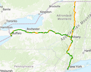 | The Empire State Trail consists of a series of smaller paths and roadways
connecting Albany to Buffalo, NYC, and Canada. There were many improvements between 2017-2021.
Zoom in on sections of the "Empire State Trail" map for surface types, construction status, and parking
locations.
Also check out the individual sections below and view RideWithGPS maps for elevation profiles.
View Map: |
| Erie Canalway Trail (East) (100 miles) 📍 ? f | |
 | The Erie Canalway trail runs between Buffalo and Albany.
There are many sections on roads, but the road sections are much shorter east of Ilion.
If you ride on the street, be aware that some are one-way only (Schenectady) so this map may not work.
See the individual sections below for the bigger trail-only sections and parking locations.
Check out the "Other" map for attractions along/near the trail.
View Map: |
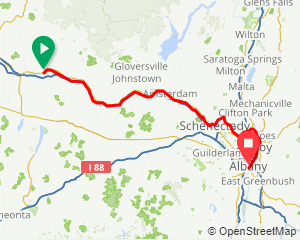
| Erie Canalway (Ilion to SCCC) (69 miles) | |
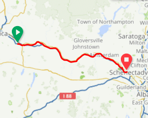 |
The trail is reportedly fully paved East of Mindenville and goes on a few sidewalks in Canajoharie, then goes all the way to Schenectady County Community College.
The author can confirm that it's paved east of Fort Plain.
In 2021, A new tunnel was added in Rotterdam Junction to eliminate an on-road section of this path.
Between Kiwanis Park and SCCC, there are a lot of great views of the river & lock 8.
View Map: Parking: |
| Mohawk Hudson Bike Trail (Schenectady to Cohoes) (19.6 miles) ? f | |
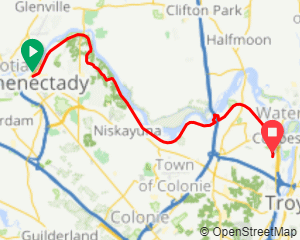 |
Views of the river at a few points including Lock 7 park. There is a 0.5 mile stretch on roadways under the twin bridges, but traffic is limited.
View Map: Parking: |
| Mohawk Hudson Bike Trail (Watervliet to Albany) (5.5 miles) ? f | |
 |
Repaved in 2021!
This path starts in Watervliet and goes through the corning preserve and ends at the U.S.S. Slater.
There is a newer 1.5 mile road-side connector path between the southern end of this path and the Albany County Rail Trail.
View Map: Parking: |
| Albany County Rail Trail (Albany to Voorheesville) (9.0 miles) 📍 ? f | |
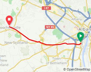 |
Fully paved from Albany to Voorheesville. Views of the Normans Kill gorge near the Albany end.
There is a 1.5 mile road-side connector path between the eastern end of this path and the Mohawk-Hudson Bike path.
View Map: Parking: |
| Albany-Hudson Electric Trail (East Greenbush to Hudson) (32.2 miles) 📍 ? f | |
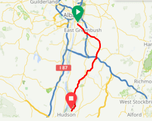 |
This path was completed in 2020 as part of the Empire State Trail system.
The first ~14 miles is mostly paved between East Greenbush and North Chatham with some on-road sections.
The next ~18 miles is mostly stone dust or on-road sections to Hudson, basically ending behind Columbia Center shopping mall.
Although the trail continues past Tractor supply, it's just a roadway/dumpsters behind the mall.
The stone dust sections of the trail are doable with a road bike (Spring 2023) but there are a few ruts from erosion so wider tires will be better.
There are several small parking lots scattered along the route. I left some off of the list because they didn't look obvious on the map.
While riding in Spring 2023, I did not see dedicated AHET bathrooms, but you may be able to find them in nearby parks and businesses.
Why is it called the Electric Trail? I'm guessing because most of it seems to parallel the right of way for electric lines.
View Map: Parking: |
| Old Champlain Canal Trail (Waterford) (7.3 miles) ? f | |
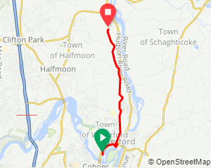 |
This path parallels the old Champlain canal in Waterford/Halfmoon, with a section passing Erie Canal Lock E-2.
This path is mostly stone dust with occasional sections of other material (paved, course gravel, natural).
In Waterford, you may want to walk your bike across the lock, or take the long way around and go up the
hill along the Champlain canal sidecut.
Traditional road bikes are not recommended.
View Map: Parking: |
| Zim Smith Trail (Ballston Spa to Mechanicville) (11.3 miles) ? f | |
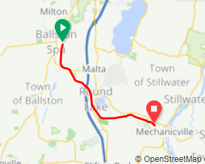 |
This fully paved path starts on Ballston Spa village streets and ends on Mechanicville village streets.
This is a great connector trail between various communities.
The most unique aspect of this path are the "fence tunnels" when you travel through the
Fairways of Halfmoon golf course in Mechanicville.
Note: when you get to Coon's Crossing, you need travel along the road for 200 feet (cross over the railroad tracks) to continue on the trail.
View Map: Parking: |
| Ballston Bicycle Path (Ballston Lake) (3.4 miles) | |
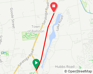 |
All paved with the exception of about 30 feet.
No views of the lake unless you ride down the hill at Outlet road, which can have a lot of traffic.
View Map: Parking: |
| Vischer Ferry Trail (Clifton Park) (5.9 miles) ? f | |
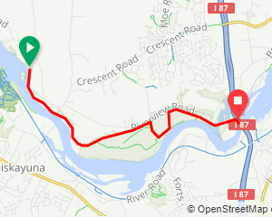 |
This trail parallels much of the old Erie canal, with a few views of the Mohawk river.
West of Ferry Drive (1.2 miles), the path is mostly packed dirt/rocks and ends with a hill at the power plant.
East of Ferry Drive (4.7 miles), the path is gravel (stone dust) and ends at the twin bridges.
If you want to extend the ride from the twin bridges and don't mind 0.9 miles of road riding,
hook up with the southwest end of the Crescent Park Trail (below)
View Map: Parking: |
| Crescent Park Trail (Clifton Park) (2.8 miles) ? | |
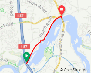 |
This path is frequently used by walkers because of the frequent views of the Mohawk river on the
Northeasternmost half of the path. It consists of about 2 miles of stone dust and 1 mile of on-road total.
If you ride another 0.1 miles on Towpath Road from the Southwest end, you end up under the twin bridges at the
the Vischer Ferry Trail (above)
View Map: Parking: |
| Railroad Run/Spa Park (Saratoga) (3.1 miles) f | |
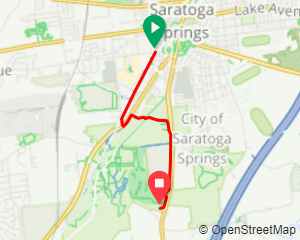 |
The author has only ridden on the railroad run section of path when flowers were blooming.
There are numerous offshoots on this trail and you can ride through the Spa Park
View Map: |
| Warren County Bikeway (9.4 miles) 📍 ? f | |
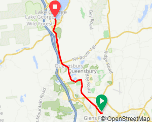 |
Fully paved. Around the halfway point here is a 1.6 mile on-road section, but the traffic is light or the shoulder is wide.
There are a lot of street crossings east of Bay Road in Glens Falls.
View Map: Parking: |
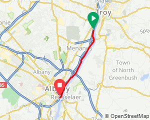
| Uncle Sam Bikeway (Troy) (3.1 miles) ? f | |
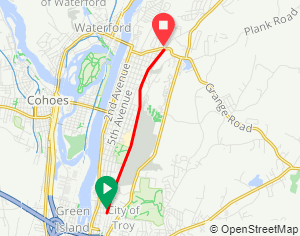 |
The author has ridden this fully paved path once. As of June 2024, the pavement of the southernmost approximately 2 miles is in
really rough shape. The northernmost 1 mile is smooth pavement. I'm not sure how common it is, but the one time I rode this path (weekend at 8AM), there was a
homeless person sleeping near the tunnel.
View Map: Parking: |
| Fonda, Johnstown & Gloversville Rail Trail (7.9 miles) | |
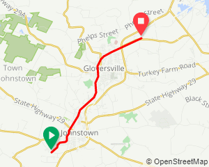 |
The author is unfamiliar with this path.
View Map: Parking: |
| Ashuwillticook Rail Trail (Lanesborough, MA) (12.1 miles) ? f | |
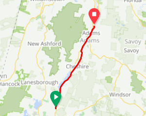 |
This is a little further from Albany, but it has nice views of the Cheshire Reservoir.
View Map: Parking: |
| Ashokan Rail Trail (Kingston) (11.5 miles) ? f | |
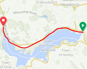 |
The author is unfamiliar with this trail and it's far from Albany, but he has it in his Strava and MMR feeds.
View Map: Parking: |